 CA
CA  AU
AU UK
UK US
US NZ
NZWhat are Geophysical surveys?
It’s the collection of Geophysical data in a systematic manner for space-borne study. Data is presented in a format that Geophysical surveys incorporate various types of geophysical methods to assess subsurface rocks' physical properties to determine the subsurface formations' geological and structural information. Different significant results like thickness, porosity, permeability, structure, depth, and mineralization overview can easily be analyzed by correctly processing and interpreting collected geophysical data. The method has a wide application in petroleum and mineral exploration.
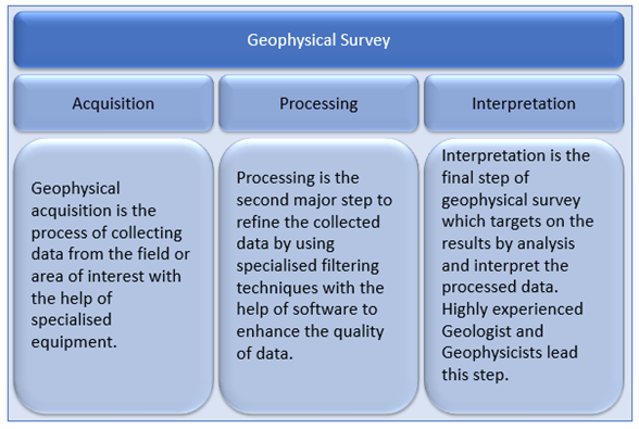
Define the fundamental procedure of Geophysical Survey
A typical geophysical survey starts with data acquisition using highly advanced geophysical instruments, which are used to collect the data from a designated area of interest.
After collecting data is done, it undergoes rigorous processing with specially designed software to remove the unwanted data and enhance its quality, intended to give the best possible results.
The final step is interpreting data that involved highly skilled and experienced geologists and geophysicists to analyze and make interpretations of the processed data sets.
Every step of the procedure is an integral part of the complete process and depends on the previous step's results. If any of the steps go wrong, the final results will be inaccurate.
However, the choice of the use of the geophysical method depends on the scope of the study. The whole geophysical survey process can be broadly classified into three main subcategories, including Acquisition, Processing, and Interpretation.
Source: Copyright © 2021 Kalkine Media Pty Ltd.
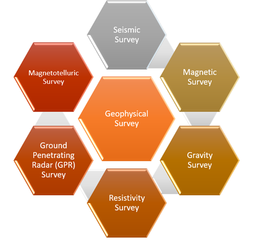
What are the types of Geophysical Survey?
There are numerous types of geophysical surveys that can be conducted from the air or on the Earth's surface to determine rocks' subsurface properties.
Airborne surveys involve radiometric, magnetic, electromagnetic or gravity surveys and are done in a grid pattern through Helicopters or light aircraft.
Whereas some ground based important surveys include Seismic, Gravity, Magnetic, and Resistivity Surveys, which are majorly used to explore oil & gas and other mineral deposits. Other methods like GPR, Magnetotellurics, Induced Polarization are also used in the industry for different applications and the study's scope.
Source: Copyright © 2021 Kalkine Media Pty Ltd.
Seismic Method:
The seismic method is the backbone of the O&G industry. It is widely used to explore subsurface deposits of Hydrocarbons. The entire array includes geophones (sensors), wires, and an energy source to create elastic waves that travel beneath the Earth's surface and get recorded on the geophone after reflecting or refracting. The recorded waves carry out the physical properties of the subsurface rocks. The data is recorded in the form of wiggly traces. This method is suitable for depth up to certain kilometres depending on the geological conditions of the area and provides the best resolution up to a particular kilometre. It is an active geophysical method.
Magnetic Method:
A magnetic method is widely used for the exploration of magnetic minerals from the subsurface. A specialized device called a Magnetometer is used to identify the variations in an area's natural magnetic field. The subsurface deposits of magnetic minerals cause the variation in the magnetic field. The instrument provides good resolutions for near-surface features and responds well to magnetic mineral deposits. It is a passive geophysical method.
Gravity Method:
The gravity method is mostly used to determine the subsurface structural features of an area. Gravimeters are used to determine the variations in gravity value at a local scale, caused by the variation in density of rocks present in that area. The deviation in actual gravity value from the theoretical value creates an anomaly and acts as the basis for identifying subsurface rock types. It is a passive geophysical method.
Resistivity Method:
It is an active geophysical method that uses an artificial energy source in the form of an electric current. The electric current is introduced into the subsurface with the help of electrodes, creating a potential difference in the ground. The voltage difference can be converted into apparent resistivity values to create the resistivity profile, providing information about soil type, composition, porosity and permeability. The method is extensively used for geological mapping, hydrological surveys and mineral exploration.
 Please wait processing your request...